Unit Overview
Before beginning a study of American History, we first have to acquire the tools necessary to study history. Background information and foundation knowledge of geography, maps, land forms, timelines, charts, graphs, and research tools is essential to help us understand topics in history. In this unit we will review information about the geography of the world, focusing more specifically on the geography of the United States. We will also explore why people study history and what tools they use to investigate and organize historical events.
Elements of Geography
MAP PROJECTIONS
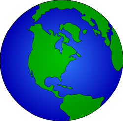
There are two basic ways to look at a picture of the Earth to understand relationships between continents and oceans. The first way is to look at a globe, which is a round model of the Earth that accurately shows its shape, lands, and directions. The second is a map which is a flat drawing of the Earth's surface.
One key flaw, or problem, of maps is that a map is a picture on something on a flat surface that is, in reality, a round surface. Unfortunately, map makers, or cartographers, cannot draw shapes of land with complete correctness onto a flat piece of paper. Because they must try and represent a round surface onto a flat surface, cartographers have to distort, or change shapes or sizes of land when drawing maps. We call the various ways that the shapes and sizes of land is changed and the different ways that maps are drawn types of map projections. Looking at different types of map projections can help our understanding of the geography of the Earth.
ELEMENTS OF A MAP
In order for a map to be helpful, it must contain certain elements. A map showing simply a picture of a location from above might not contain information to be helpful in our study of geography. In order for a map to communicate more information, it must contain other features. As historians and geographers, we must be able to identify these features and use them to gather information from the maps. Basic features found on most maps include a title, a legend or key, a scale bar, a compass rose, and lines of latitude and longitude.
TYPES OF MAPS
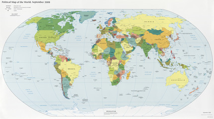
Using these projections and tools, cartographers can create maps to display many different types of information. The type of map you see most often in the walls of classrooms are called political maps. Political maps have their name because they focus on political features of the Earth, such as boundaries of countries or states or cities. While political maps might also show rivers, oceans, or other basic physical features, this is not the primary, or main purpose, of political maps. Maps that have the primary focus of showing the shape of land by showing land forms and other physical features of the Earth are in the category of physical maps. The focus of physical maps will be features of the land such as mountains, lakes, rivers, valleys, etc. While they might contain information such as borders and cities, their primary focus is to show the physical shape of the land. Maps that include more detailed information about a specific category of information are called thematic maps. Thematic maps might include information about the climate, natural resources, historic information, population, or exports.
LAND FORMS
For our study of history, we need to become familiar with the different shapes found on the Earth. The shapes on the surface of the Earth are different land forms. Throughout history, as well as today, land forms have influences where people live and how they live.
One of the most interesting things about the United States is the variety of land forms found within our borders. These land forms influenced history by affecting how the country was settled and the types of industries that developed in the United States over time. Even today, mountains, rivers, oceans, plains, deserts, bays, peninsulas, islands, straits, lakes, hills, and other land forms affect
There are two basic ways to look at a picture of the Earth to understand relationships between continents and oceans. The first way is to look at a globe, which is a round model of the Earth that accurately shows its shape, lands, and directions. The second is a map which is a flat drawing of the Earth's surface.
One key flaw, or problem, of maps is that a map is a picture on something on a flat surface that is, in reality, a round surface. Unfortunately, map makers, or cartographers, cannot draw shapes of land with complete correctness onto a flat piece of paper. Because they must try and represent a round surface onto a flat surface, cartographers have to distort, or change shapes or sizes of land when drawing maps. We call the various ways that the shapes and sizes of land is changed and the different ways that maps are drawn types of map projections. Looking at different types of map projections can help our understanding of the geography of the Earth.
ELEMENTS OF A MAP
In order for a map to be helpful, it must contain certain elements. A map showing simply a picture of a location from above might not contain information to be helpful in our study of geography. In order for a map to communicate more information, it must contain other features. As historians and geographers, we must be able to identify these features and use them to gather information from the maps. Basic features found on most maps include a title, a legend or key, a scale bar, a compass rose, and lines of latitude and longitude.
TYPES OF MAPS
Using these projections and tools, cartographers can create maps to display many different types of information. The type of map you see most often in the walls of classrooms are called political maps. Political maps have their name because they focus on political features of the Earth, such as boundaries of countries or states or cities. While political maps might also show rivers, oceans, or other basic physical features, this is not the primary, or main purpose, of political maps. Maps that have the primary focus of showing the shape of land by showing land forms and other physical features of the Earth are in the category of physical maps. The focus of physical maps will be features of the land such as mountains, lakes, rivers, valleys, etc. While they might contain information such as borders and cities, their primary focus is to show the physical shape of the land. Maps that include more detailed information about a specific category of information are called thematic maps. Thematic maps might include information about the climate, natural resources, historic information, population, or exports.
LAND FORMS
For our study of history, we need to become familiar with the different shapes found on the Earth. The shapes on the surface of the Earth are different land forms. Throughout history, as well as today, land forms have influences where people live and how they live.
One of the most interesting things about the United States is the variety of land forms found within our borders. These land forms influenced history by affecting how the country was settled and the types of industries that developed in the United States over time. Even today, mountains, rivers, oceans, plains, deserts, bays, peninsulas, islands, straits, lakes, hills, and other land forms affect
Historical Thinking
HISTORICAL THINKING SKILLS
Historians are people who study history as their job. Because they are studying people and events that happened a long time ago, historians must use clues to put together a picture of what life was like in the past. Historians must investigate historical events by looking at the evidence that they can find. This evidence can come in the form of documents, journals, artifacts, photographs, songs, artwork, political cartoons, maps, and other historical items. Once they find evidence, historians try to determine any information about life in that period of time. One of the most common forms of evidence we will see in American History is documents. When reading documents in history, you should always ask yourself questions:
Does the author have an obvious bias?
What is the context of the document?
What do you think the author’s perspective is?
TOOLS OF HISTORIANS
Once historians have created a picture of life in the past, they use a variety of tools to organize their information. The most common would be writing non-fiction about life in the past, as is done in history text-books. Other tools used by historians include charts, graphs, historical maps, and timelines. Timelines are like a one-axis graph that show the relationships between when different events happened in history. They can cover small or large periods of time and can be used to show events related to anything in history.
Historians are people who study history as their job. Because they are studying people and events that happened a long time ago, historians must use clues to put together a picture of what life was like in the past. Historians must investigate historical events by looking at the evidence that they can find. This evidence can come in the form of documents, journals, artifacts, photographs, songs, artwork, political cartoons, maps, and other historical items. Once they find evidence, historians try to determine any information about life in that period of time. One of the most common forms of evidence we will see in American History is documents. When reading documents in history, you should always ask yourself questions:
Does the author have an obvious bias?
- Bias – An unbalanced or unfair opinion about a subject
What is the context of the document?
- Context – the facts and circumstances that surround a situation or event in history
What do you think the author’s perspective is?
- Perspective – the point of view through which we view history
TOOLS OF HISTORIANS
Once historians have created a picture of life in the past, they use a variety of tools to organize their information. The most common would be writing non-fiction about life in the past, as is done in history text-books. Other tools used by historians include charts, graphs, historical maps, and timelines. Timelines are like a one-axis graph that show the relationships between when different events happened in history. They can cover small or large periods of time and can be used to show events related to anything in history.
