Unit Overview
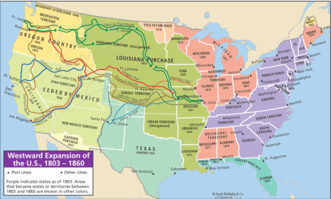
A theme in America in the 19th century was the acquiring of new lands and the efforts of Americans to expand into new territories. Thomas Jefferson's purchase of the Louisiana Territory doubled the size of the nation and was the first of several large land additions to the continental United States.
Once the new land was acquired, Americans began to expand into the new territories. People moved west for many reasons; some were families that were seeking the promise a new life on a farm in the Oregon Territory. Others were young, single men hoping to strike it rich by finding gold in California. Still another group was fleeing religious persecution and was traveling to Utah to set up their own community away from judgment of others. While some people were traveling west, residents of the modern state of Texas fought for their independence from Mexico.
Regardless of the reasons for why Americans were traveling west, they were all fulfilling parts of a belief that it was the duty of Americans to occupy all of the land on the continent. This belief was called Manifest Destiny. The movement of Manifest Destiny was so successful that by 1856, the continental United States had reached its present day size.
What effects did the Louisiana Purchase have on the United States?

There are two basic ways to look at a picture of the Earth to understand relationships between continents and oceans. The first way is to look at a globe, which is a round model of the Earth that accurately shows its shape, lands, and directions. A map is a flat drawing of the Earth's surface.
One key flaw of maps is that a map is a picture on something on a flat surface that is, in reality, a round surface. Unfortunately, map makers, or cartographers, cannot draw shapes of land with complete correctness onto a flat piece of paper. Because they must try and represent a round surface onto a flat surface, cartographers have to distort, or change shapes or sizes of land when drawing maps. We call the various ways that the shapes and sizes of land is changed and the different ways that maps are drawn types of map projections. Looking at different types of map projections can help our understanding of the geography of the Earth.
In order for a map to be helpful, it must contain certain elements. A map showing simply a picture of a location from above might not contain information to be helpful in our study of geography. In order for a map to communicate more information, it must contain other features. As historians and geographers, we must be able to identify these features and use them to gather information from the maps. Basic features found on most maps include a title, a legend or key, a scale bar, a compass rose, and lines of latitude and longitude.
Using these projections and tools, cartographers can create maps to display many different types of information. The type of map you see most often in the walls of classrooms are called political maps. Political maps have their name because they focus on political features of the Earth, such as boundaries of countries or states or cities. While political maps might also show rivers, oceans, or other basic physical features, this is not the primary, or main purpose, of political maps. Maps that have the primary focus of showing the shape of land by showing land forms and other physical features of the Earth are in the category of physical maps. The focus of physical maps will be features of the land such as mountains, lakes, rivers, valleys, etc. While they might contain information such as borders and cities, their primary focus is to show the physical shape of the land. Maps that include more detailed information about a specific category of information are called thematic maps. Thematic maps might include information about the climate, natural resources, historic information, population, or exports.
